Real-time Sea Level Forecasting System for Venice
Minimizing flood impact with water-level prediction technology
- Location: Venice, Italy
- Date: 2014 – 2021
- Client: Il Meteo, s.r.l.
- Project Type: Flood risk reduction
Keeping Venetians and tourists above the waterline with sea-level prediction
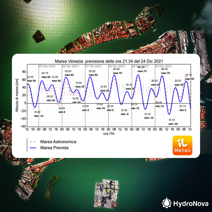
The cultural Italian city of Venice has seen higher and more frequent flooding caused by a combination of rising sea levels and stronger storm surges that upends city life and critical infastructure. Knowing when waters would rise and by how much has been a perpetual challenge. Italian public weather forecasting service, Il Meteo, commissioned Hydro Nova to design an operational tool for forecasting the water levels in Venice in real-time that could warn the public of impending hazard and help city authorities keep people and assets safe.
Our team designed and built the first operational sea level prediction tool for Venice, coupling models for wind, storms, waves and tides with precise lagoon and urban topography. Today, Il Meteo broadcasts continuous sea level data from the tool as a service to the general public and city planners.
The tool provides Venice city organizers longer lead times to schedule evacuations and make contingencies to keep crowds and assets safe when the surge waters rise.
Services Provided
Wave propagation modeling
Our expert team developed a unique computational model of wave behavior, a key innovation that makes sea level prediction possible in Venice’s complex lagoon environment.
Sea-level tool calibration
We adapted the model to give an accurate simulation of the unique Venice environment, including the complex Venice lagoon, wind, waves, ocean and meteorological and astronomical tides.
Real-time sea-level simulation
Our solution was to build a system of programs to solve time-dependent problems in a two- dimensional finite method, based on the ADCIRC module, allowing for precise storm water prediction in real-time.
System automation
We made the tool operational, automating the running of the model to generate 7-day forecasts of sea level every 6 hours, processed for the end-user.